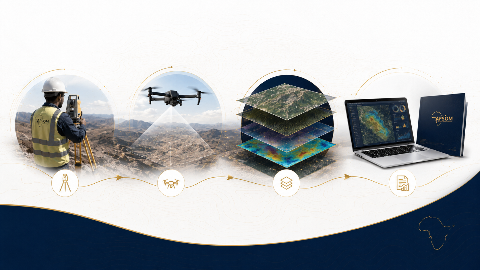
PROJECT METHODOLOGY
From Field Data to Actionable Insight
A proven, systematic 8-stage process that ensures quality-controlled delivery of every project — from initial scoping through to final client handover.
Systematic. Transparent.
Quality-Driven.
At AFSOM, every project follows a structured, systematic approach that has been refined through field experience and professional standards. Our 8-stage methodology provides a clear framework that ensures quality, consistency, and accountability from project initiation to completion.
Each stage has defined objectives, activities, quality controls, and measurable outputs — giving our clients confidence that their project is being managed professionally and transparently. The framework ensures that critical activities are never overlooked, quality is built in at every stage, and clients remain informed and engaged throughout the project lifecycle.

Field Survey & Data Collection

Data Processing & Interpretation
How We Deliver Every Project
Scoping and Planning
The foundation of every successful project is thorough scoping and planning. We engage with the client to define project objectives, establish technical requirements, determine deliverables, identify constraints, and develop a detailed work plan. This stage ensures alignment between client expectations and project execution.
To establish a clear, documented understanding of project scope, methodology, timeline, resources, and deliverables that provides a solid foundation for successful project execution.
- Client consultation to define project objectives, success criteria, and intended use of deliverables
- Desktop review of existing data, geological literature, maps, reports, and imagery
- Definition of technical specifications including coordinate systems, accuracy requirements, and data standards
- +4 more
Approved project scope document including work plan, schedule, methodology statement, HSE plan, and budget.
Mobilization and Logistics
Following approved planning, we assemble the project team, prepare equipment, arrange logistics, and deploy to the field. This stage covers all preparatory activities required to ensure the field team can work safely, efficiently, and productively from day one of field operations.
To deploy a properly equipped, briefed, and organized field team to the project area with all necessary resources for safe and efficient survey execution.
- Assemble project team with appropriate skills, experience, and local knowledge
- Conduct project kick-off briefing covering technical methodology, HSE requirements, and logistics
- Calibrate and test all survey instruments, GNSS equipment, and field devices
- +4 more
Fully mobilized field team with calibrated equipment, established logistics, and confirmed site access.
Field Survey Execution
The core operational phase where geological observations are made, measurements taken, samples collected, and data captured in the field. Teams work systematically through planned traverses, applying the defined methodologies while adapting to field conditions within the approved work framework.
To systematically collect high-quality geological and survey data across the project area in accordance with the approved methodology and safety plan.
- Establish survey control network with primary and secondary control points
- Execute geological traverses recording lithologies, structures, alteration, and mineralization
- Conduct topographic surveys capturing terrain features, breaklines, and spot heights
- +5 more
Raw field dataset including geological observations, survey measurements, samples despatched to laboratory, photographs, and daily progress reports.
Data Collection
Beyond the initial field survey, this stage encompasses the systematic collation of all data sources relevant to the project. This includes field observations, survey measurements, laboratory analytical results, remote sensing data, existing reports, and any third-party datasets that contribute to the geological understanding of the project area.
To compile all available and newly acquired data into an organized, documented dataset that comprehensively covers the data requirements of the project.
- Download and archive all field survey data from instruments and tablets
- Register and track all submitted samples through laboratory analysis
- Acquire and preprocess satellite imagery and remote sensing data
- +4 more
Compiled project dataset with all field observations, measurements, laboratory results, remote sensing data, and reference information organized and documented.
Data Processing
Raw data is processed through a series of technical workflows to transform field observations and measurements into structured, validated, and analysis-ready datasets. This stage involves survey adjustment, geochemical data processing, image processing, and spatial data preparation.
To transform all raw project data into validated, analysis-ready formats through systematic processing, adjustment, and integration workflows.
- Process and adjust GNSS and Total Station survey observations to project coordinate system
- Process UAV imagery to produce orthophotos, digital surface models, and point clouds
- Compile geochemical analytical results with quality control assessment
- +4 more
Processed and validated datasets ready for geological interpretation including adjusted survey coordinates, orthophotos, GIS geodatabase, and geochemical results.
Data Interpretation
Processed data is interpreted by experienced geologists to extract geological meaning, identify patterns, develop models, and draw conclusions. This is the analytical stage where data becomes geological knowledge, forming the basis for maps, reports, and recommendations.
To derive meaningful geological understanding from processed data through professional interpretation, integration of multiple data types, and application of geological knowledge.
- Integrate field observations with laboratory results and remote sensing interpretations
- Interpret geological boundaries, structural framework, and stratigraphic relationships
- Analyze structural data using stereographic projection and kinematic analysis
- +4 more
Geological interpretation including maps, cross-sections, structural analysis, geochemical interpretation, and geological model with supporting rationale.
Reporting and Delivery
Interpreted results are compiled into professional technical reports and deliverables. This stage involves drafting, figure preparation, internal review, revision, and finalization of all project outputs in accordance with client requirements and professional standards.
To produce clear, accurate, and professional deliverables that effectively communicate project results, interpretations, and recommendations to the client.
- Draft technical report with logical structure covering methodology, results, interpretation, and recommendations
- Prepare report-quality maps, figures, cross-sections, and data visualizations
- Compile appendices including raw data, laboratory certificates, and methodology details
- +4 more
Final project deliverables package including technical report, maps, figures, GIS data, terrain models, and any other agreed project outputs.
Client Handover
The final stage involves formal delivery of all project outputs, presentation of findings, discussion of results and recommendations, and project closure. We ensure that the client fully understands the deliverables, can use them effectively, and has the opportunity to ask questions and provide feedback.
To ensure successful knowledge transfer, client satisfaction, and formal project closure with all deliverables accepted and understood.
- Present project results, key findings, and recommendations to client team
- Walk through all deliverables explaining content, format, and intended use
- Answer client questions and provide clarification on technical matters
- +5 more
Formally accepted deliverables, client sign-off documentation, satisfied client, and completed project archive.
Quality at Every Stage
Quality control is not a final step — it is embedded in every stage of our methodology. From calibrated instruments before field deployment, through daily data reviews during survey execution, to independent peer review of all reports before delivery, quality assurance is continuous and systematic. Each stage includes defined quality control activities that ensure the integrity, accuracy, and reliability of our work.
Our commitment to quality means that clients receive deliverables they can rely on with confidence — whether for exploration targeting, engineering design, investment decisions, or regulatory submissions.
Calibrated Instruments
All equipment verified before field deployment
Daily Data Reviews
Continuous validation during survey execution
Independent Peer Review
All reports reviewed before client delivery
From Field to Final Report
Start Your Project With a Proven Process
Discuss your project requirements and discover how our systematic methodology delivers reliable geological intelligence.