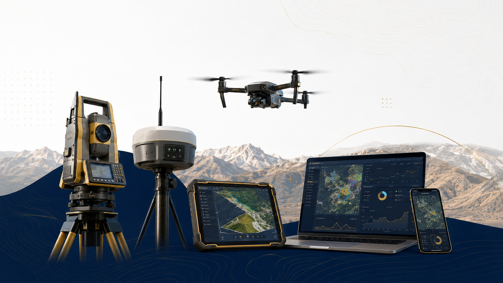
TECHNOLOGY & EQUIPMENT
Advanced Tools for Accurate Survey Intelligence
Professional instruments, platforms, and software systems that power reliable geological and survey data delivery.
Technology is at the heart of reliable geological and survey services. At AFSOM, we invest in professional-grade field instruments, aerial platforms, and industry-standard software to ensure that every measurement is precise, every dataset is properly managed, and every deliverable meets the highest professional standards. Below is an overview of the technology categories that support our work across 16 core systems.

Field Equipment
Professional-grade survey and geological instruments deployed by our field teams to capture accurate, reliable measurements in diverse terrain and conditions.
Total Station
High-precision optical-electronic instrument for measuring horizontal and vertical angles and distances. Used for detailed topographic surveys, engineering set-out, control traverse, and deformation monitoring with millimeter-level accuracy.
- Angular accuracy of 1 to 5 arc-seconds
- Distance measurement range up to several kilometers with reflector
- Reflectorless measurement capability for inaccessible targets
- Onboard data storage and field coding for efficient survey workflow
- Ruggedized construction for reliable operation in field conditions
GNSS Receivers
Multi-constellation satellite positioning receivers providing real-time and post-processed coordinate solutions. Essential for survey control establishment, topographic data capture, and sample location positioning.
- Multi-constellation tracking of GPS, GLONASS, Galileo, and BeiDou
- Real-time kinematic positioning with centimeter-level accuracy
- Static survey capability for high-precision control network establishment
- Integrated data logging with external device connectivity
- Long battery life and rugged field design for extended survey campaigns
Field Tablets
Ruggedized tablet computers running mobile GIS and field data capture software. Enable real-time digital geological mapping, sample registration, photo documentation, and GPS-tagged observation recording.
- Sunlight-readable display for outdoor use in bright conditions
- Integrated GNSS receiver for position tagging
- Rugged construction with water and dust resistance
- Long battery life with hot-swappable battery options
- Compatible with professional field GIS and data collection applications
Survey Accessories
Complementary field equipment supporting survey operations including tripods, prisms, leveling staffs, range poles, and measurement tapes. Ensures accurate instrument setup and target measurements.
- Carbon fiber or aluminum tripods with stable locking mechanisms
- 360-degree prisms for Total Station target measurements
- Telescopic range poles with built-in bubble levels
- Heavy-duty measurement tapes with metric and imperial graduations
- Tribrachs and adaptors with optical and laser plummets
Geological Compass
Specialized compass with clinometer for measuring planar and linear geological features. Used to record strike, dip, dip direction, plunge, and trend of bedding, foliation, joints, faults, and fold axes.
- Precision compass with graduated circle and damping mechanism
- Integrated clinometer for dip and plunge angle measurement
- Mirror with sighting line for accurate bearing determination
- Robust housing resistant to shock and moisture
- Declination adjustment for local magnetic variation
Sampling Equipment
Comprehensive geological sampling kit including rock hammers, chisels, sample bags, GPS units, field notebooks, cameras, and sample preparation tools. Supports systematic collection of representative geological samples.
- Geological hammers in various weights for different rock types
- Chisels and pry bars for sample extraction from outcrop
- Heavy-duty sample bags with drawstring closures and labeling panels
- Hand lens with magnification for mineral identification in the field
- Portable sample preparation tools for preliminary field assessment
Aerial and Remote
Airborne and satellite-based platforms and sensors that provide synoptic-scale imagery, elevation data, and spectral information for geological interpretation and terrain analysis.
UAV / Drone
Unmanned aerial vehicles equipped with high-resolution cameras and optional multispectral sensors. Used for site-scale photogrammetric surveys, orthophoto production, terrain modelling, and inspection of inaccessible areas.
- High-resolution RGB camera with mechanical shutter for sharp imagery
- Multispectral sensor option for vegetation and mineral discrimination
- Flight planning software with terrain following and automated mission execution
- GNSS-enabled with real-time or post-processed georeferencing
- Flight endurance sufficient for mapping moderate to large site areas per mission
Photogrammetry
UAV-based photogrammetric processing chain that converts overlapping aerial images into orthophoto mosaics, digital surface models, and three-dimensional point clouds for mapping and analysis.
- Structure-from-Motion processing for automated 3D reconstruction
- Ground control point integration for survey-grade accuracy
- Outputs include orthophoto, digital surface model, and dense point cloud
- Compatible with industry-standard coordinate systems and export formats
- Accuracy scalable from centimeter to decimeter level depending on survey design
Satellite Imagery
Multispectral and high-resolution satellite imagery acquired from commercial and open-access platforms. Provides regional to local-scale data for geological interpretation, structural analysis, and land-cover assessment.
- Spatial resolutions ranging from sub-meter to tens of meters
- Multispectral bands covering visible, near-infrared, and shortwave-infrared wavelengths
- Stereo-pair capability for digital elevation model extraction
- Archival imagery available for multi-temporal change detection studies
- Radiometric calibration for quantitative analysis and classification
Remote Sensing
Analytical techniques applied to satellite and aerial imagery to extract geological, structural, and environmental information. Includes spectral interpretation, band ratio analysis, and image classification.
- Band ratio and spectral index calculation for mineral and alteration detection
- Supervised and unsupervised image classification for land-cover mapping
- Lineament extraction using spatial filtering and edge-detection algorithms
- Multi-temporal change detection for land-use and environmental monitoring
- Integration with digital elevation models for terrain-corrected analysis
Software and Data
Industry-leading software platforms and data management tools that support spatial data processing, geological modelling, visualization, and reporting workflows.
GIS Platforms
Professional geographic information system software for spatial data management, geodatabase design, digital cartography, and spatial analysis. The central platform for integrating and visualizing all project spatial data.
- Vector and raster data management with advanced editing tools
- Comprehensive geoprocessing framework with hundreds of analytical tools
- Professional cartographic layout and map production capabilities
- Support for industry-standard spatial data formats and coordinate systems
- Extensible through scripting for custom workflows and automation
Spatial Databases
Enterprise-grade spatial database systems for storing, querying, and managing large volumes of geological, survey, and geospatial data with multi-user access, version control, and robust backup capabilities.
- Spatial data types with SQL-based query and analysis functions
- Multi-user concurrent access with transaction management
- Version control and archiving for tracking data changes over time
- Integration with desktop and web-based GIS applications
- Scalable architecture supporting large project datasets
Terrain Modelling
Specialized software for generating, editing, and analyzing digital elevation models, contours, and terrain surfaces. Supports hydrological modelling, viewshed analysis, and volumetric calculations.
- Surface generation from survey points, contours, and breaklines
- Contour interpolation with user-specified intervals and smoothing
- Triangulated irregular network and grid-based surface representation
- Cut-and-fill and stockpile volume calculation tools
- Terrain analysis including slope, aspect, hillshade, and watershed delineation
Dashboards
Interactive web-based dashboard platforms for visualizing geological and survey data. Enable clients to explore data, filter by attributes, view maps, and generate summary statistics through an intuitive interface.
- Web-based interface accessible from desktop and mobile devices
- Interactive maps with layer toggling, zoom, and feature identification
- Chart and graph widgets linked to underlying spatial data
- User-configurable filters for exploring data by attribute, date, and location
- Export functionality for downloading filtered data and map views
Analytical Tools
Statistical and geospatial analysis tools for processing geochemical data, structural measurements, and survey observations. Support quantitative interpretation and data-driven geological insight.
- Statistical analysis of geochemical datasets including summary statistics and anomaly detection
- Stereographic projection and structural data analysis with kinematic interpretation
- Spatial interpolation methods for surface generation from point observations
- Custom scripting and workflow automation for repetitive analytical tasks
- Integration with GIS and database platforms for seamless data exchange
Reporting Systems
Document preparation and report compilation tools for producing professional technical reports with embedded maps, figures, tables, and cross-references. Support consistent corporate branding and formatting.
- Template-based document production for consistent report formatting
- Integration with GIS for live-linked map and figure insertion
- Automatic cross-referencing of tables, figures, and appendices
- Multi-author collaboration with version tracking and change management
- Output to PDF and print-ready formats with high-resolution graphics
Data to Decision Pipeline
From raw geological observations to confident, actionable decisions — a systematic, quality-controlled pipeline that transforms data into insight.
CAPTURE
Systematic collection of field observations, survey measurements, samples, and imagery using calibrated instruments and standardized protocols.
VALIDATE
Rigorous quality control checks to verify data completeness, positional accuracy, attribute consistency, and compliance with project specifications.
INTEGRATE
Consolidation of field data, laboratory results, remote sensing interpretations, and existing datasets into a unified geospatial database.
ANALYZE
Geological interpretation, spatial analysis, statistical processing, and modelling to extract meaningful information and insights from integrated datasets.
VISUALIZE
Creation of maps, cross-sections, 3D models, dashboards, and figures that communicate geological information clearly to diverse audiences.
REPORT
Compilation of findings, interpretations, and recommendations into professional technical reports that support confident decision-making.

Interested in Our Technical Capabilities?
See how our technology stack supports every project stage.